If you’re looking for a quick mountain escape in North Carolina’s Blue Ridge, Mount Jefferson State Natural Area is one of the most rewarding stops you can make. This 1,188-acre park in Ashe County, just outside the creative downtown of West Jefferson, packs serious elevation and natural beauty into a small footprint. The mountain rises 1,600 feet above the surrounding valleys to a peak of approximately 4,683 feet — and the area has been a local landmark since the 1700s, when Thomas Jefferson and his father, Peter Jefferson, surveyed the land.
In 1974, Mount Jefferson earned National Natural Landmark status thanks to its extraordinary biodiversity — more than 700 plant species and rare birds like the golden-winged warbler call the mountain home. The park offers roughly five miles of well-maintained trails that wind through oak forests, rhododendron thickets, and dramatic rocky outcrops, delivering the kind of views you’d expect at much busier mountain destinations — without the crowds.
Whether you’re looking for an easy summit walk, a peaceful ridgeline loop, or a real climb that earns the view, this guide breaks down each trail with what to expect, where it goes, and how to make the most of your visit. The images below are clickable, allowing you to view more pictures and a YouTube video of each trail. If you’d rather see everything at a glance, our list of trails is also available in a table format. Happy adventuring!
Before you head out, it’s a good idea to check the NC State Parks website for any current trail updates.
Table of Contents
Lost Province Trail

🥾 A 0.75-mile loop that winds through a virgin oak-chestnut forest, branching off the Rhododendron Trail near the Luther Rock overlook.
🌸 In late spring and early summer, the trail features blooming rhododendrons and mountain laurel.
🧭 Rated moderate, the trail avoids the steepest and rockiest sections of the mountain.
🏞️ Year-round access from the picnic area parking lot makes this a great, peaceful extension to a summit-area visit.
🗺️ The name “Lost Province” refers to the historic isolation of Ashe, Alleghany, and Watauga counties, separated from the rest of North Carolina by the Blue Ridge Mountains for more than a century.
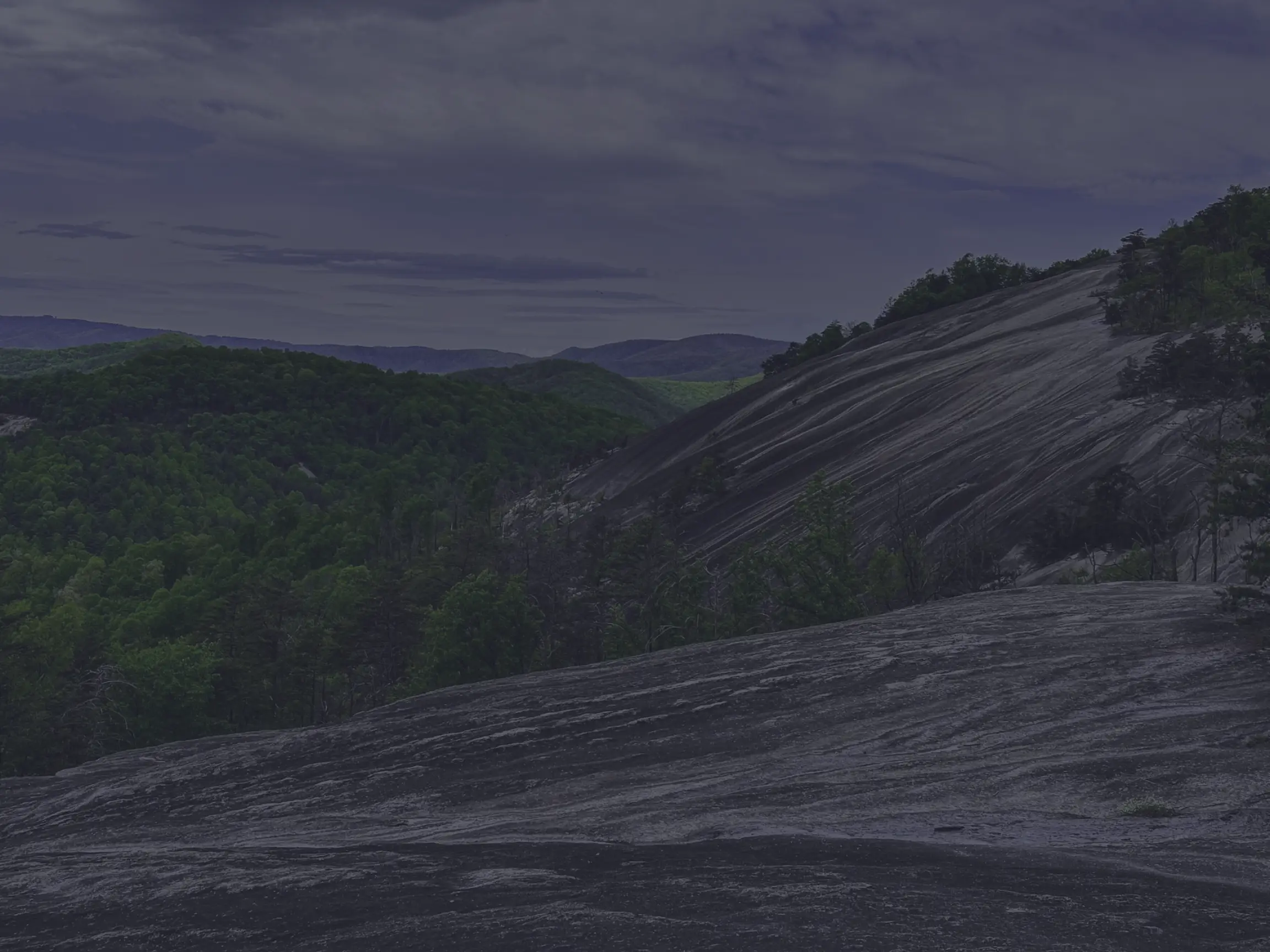
Luther Rock

🌄 A granite outcrop that’s one of the most dramatic observation points in the entire park.
🌲 The rock sits at the highest elevation of a narrow, exposed ridge, with sweeping views of the South Fork New River Valley, the Blue Ridge escarpment, and the distant Virginia highlands.
🥾 Accessed via a short trail off the Rhododendron Trail, which winds through red oak woods, rhododendron, and mountain laurel before ending in a narrow, rocky path to the outcrop.
🌌 At the top, you’ll find a natural amphitheatre with sheer cliffs and expansive views to the southeast and northwest.
🍁 In autumn, golden foliage frames the surrounding peaks; in spring, mist drifts over the ridges for a moody, atmospheric scene.
☁️ Even on foggy days, Luther Rock is genuinely beautiful — situated about 1,100 feet above the valley floor, with a presence that comes through no matter the weather.
Mountain Ridge Trail

🥾 A 2-mile out-and-back hike through hardwood forests, wildflowers, and rocky outcrops.
🌳 The trail starts near the park office at the base of the mountain and climbs steadily through northern hardwood forest.
👀 Multiple overlooks deliver scenic views of the Blue Ridge Mountains along the way, including the Jefferson Overlook — a panoramic vista that’s a real highlight of the climb.
⛰️ Rated strenuous by the park, the trail has steep and rocky sections that earn that rating in places — though with steady pacing, it’s well within reach for hikers with some experience.
🔗 Connects to the upper ridge trails from the upper picnic area via the Summit Trail, allowing for a fuller day on the mountain.
Rhododendron Trail
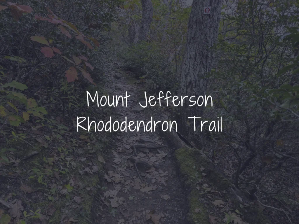
🌸 A scenic 1.1-mile loop, splitting off from the Summit Trail near the upper picnic area.
🌳 The trail winds through a shaded, high-elevation ridge forest of rare old-growth northern red oaks and dense rhododendron understory.
🌺 In late June and early July, pink and white rhododendrons and mountain laurel burst into bloom, forming leafy tunnels along the path — one of the most beautiful seasonal experiences in the park.
🪧 Educational signs along the trail explain the local ecology and how rhododendron and mountain laurel help stabilize the rocky Appalachian soil.
🏞️ Occasional views of the Blue Ridge peaks open up between the trees.
🔭 The Rhododendron Trail is the only access to Luther Rock and the Lost Province Trail — making it essential to any meaningful day on the mountain.
👨👩👧👦 Rated strenuous by the park, though we found it manageable for families with hiking experience.
Spur Trail

🌳 A peaceful, scenic half-mile path connecting the Sunset Overlook to the Mountain Ridge Trail.
🌲 The trail winds through shady woods, rocky spots, and tall trees, offering a quiet, sheltered forest experience.
🚶♂️ Fewer hikers use this trail, so it feels less crowded and more serene than the summit-area paths.
🥾 Rated moderate, with a gentle climb averaging a 9% grade.
⏱️ Ideal for a quick morning walk, a connector to longer hikes, or simply enjoying the tranquil forest before reaching another scenic overlook.
Summit Trail

🏔️ A short, accessible 0.3-mile trail that leads to the peak of Mount Jefferson at approximately 4,683 feet.
🥾 Rated strenuous by the park, though we found it more moderate in practice — short, with a gentle gravel surface and a manageable climb.
🚻 Starts at the summit picnic area parking lot, with restrooms, pavilions, and tables on site.
🌳 The path winds through a lush forest of northern red oaks, mountain laurel, and rhododendron.
👨👩👧👦 Ideal for families, beginners, and visitors of all ages looking for a quick outing.
🌱 The park is a National Natural Landmark with more than 700 plant species, including rare highland flora.
⛅ The summit marker is located right next to the National Weather Service station.
🌄 For panoramic views, continue along the Rhododendron Trail to Luther Rock — the views from the summit itself are limited by the surrounding forest.

Your Complete Guide to Hiking Trails at Elk Knob State Park
Elk Knob State Park is one of North Carolina’s most rewarding mountain destinations — a 4,400-…

A Complete Guide to the Trails at Carolina Beach State Park
Tucked along the Cape Fear River on Pleasure Island, Carolina Beach State Park is one of southeaster…

The Complete Guide to Hiking Trails in Lansing, NC
Set in the rolling hills of Ashe County, just a stone’s throw from the Virginia and Tennessee …

Exploring Ashe County Park: A Hiker’s Guide to North Carolina’s Mountain Gem
If you’re searching for the best hiking trails at Ashe County Park in North Carolina, you̵…

Mountain Masterpieces: A Guide to the Ben Long Frescoes of Ashe County
In the quiet corners of Ashe County, where the Blue Ridge Mountains meet peaceful valleys, thereR…
Granite, Grunts, and Glory: A Day on the Stone Mountain Loop Trail
The Stone Mountain Loop Trail is the signature hike at Stone Mountain State Park in North Carolina —…