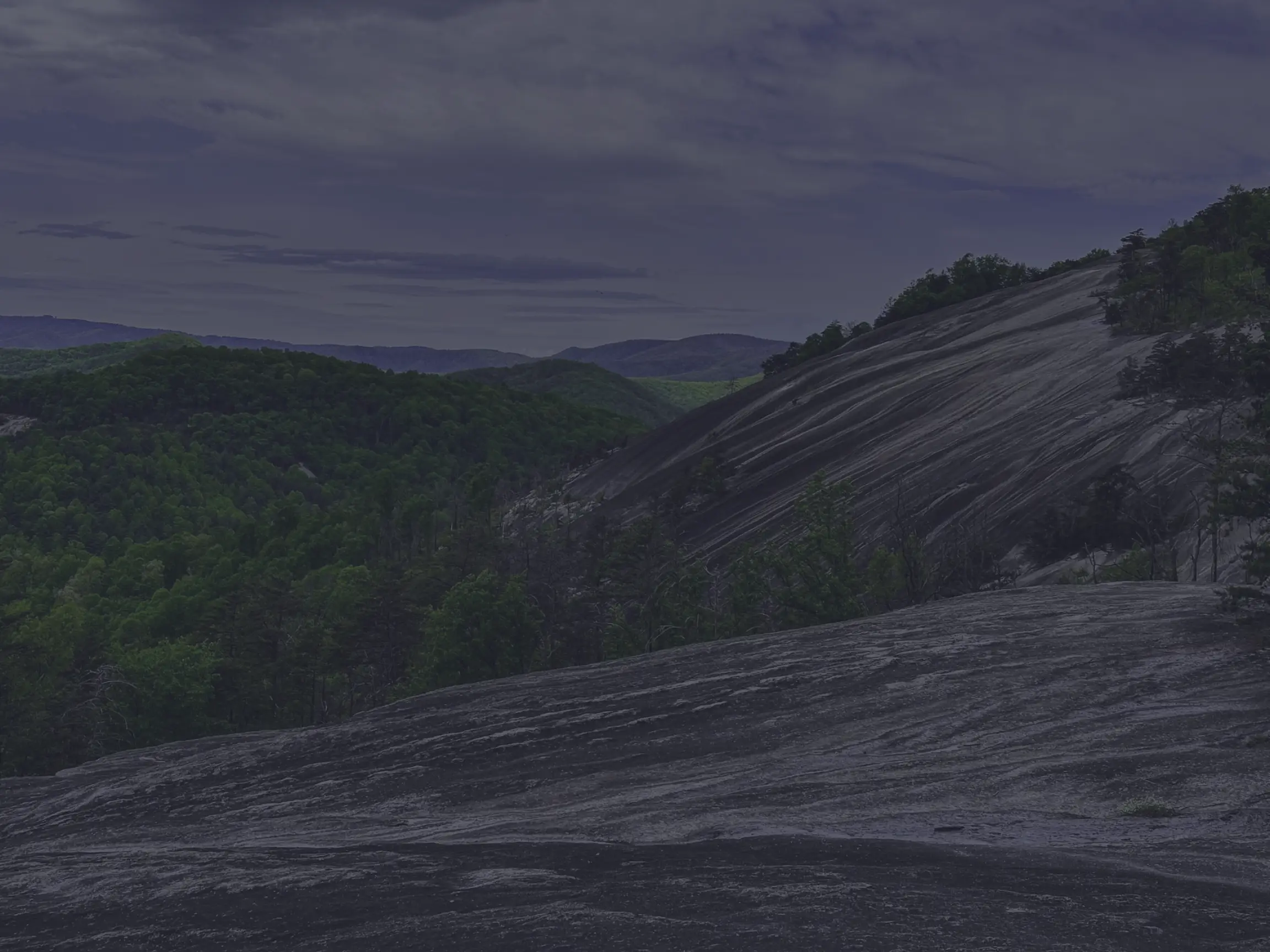
If there’s one stop at Mount Jefferson State Natural Area that visitors talk about long after their visit, it’s Luther Rock. Set at the highest point of a narrow, exposed ridge near West Jefferson, this granite outcrop sits roughly 1,100 feet above the valley floor and delivers some of the most dramatic views in Ashe County — sweeping panoramas of the South Fork New River Valley, the Blue Ridge escarpment, and the distant peaks of the Virginia highlands. Be sure to check out the YouTube video and pictures below to get a feel for the spot before you go — or to relive the visit after.
A Granite Outcrop with Real Drama
Luther Rock isn’t a casual overlook — it’s a true mountain perch. The outcrop rises at the highest point of a narrow ridge, and as you approach, the trees give way to open sky, sheer rock cliffs, and a natural amphitheater of stone that opens up to the southeast and northwest. The drop-offs on either side are real, and the views genuinely earn the climb.
The setting is even more striking because of how it pairs ecological richness with raw geology. The walk passes through red oak woodlands and dense thickets of rhododendron and mountain laurel — peaceful, layered, deeply Appalachian — before opening onto bare rock and panoramic views.
How to Get There
Luther Rock is accessed via the Rhododendron Trail, which is the main path to the outcrop. The final approach is a narrow, rock-strewn path that requires careful footing — particularly when conditions are wet — but it’s manageable for most reasonably fit hikers and well worth the effort.
What You’ll See
The views from Luther Rock change dramatically with the seasons and the weather:
- Sweeping panoramas of the South Fork New River Valley, the Blue Ridge escarpment, and the distant peaks of the Virginia highlands.
- Fall foliage lights up the surrounding peaks in classic Blue Ridge color.
- Spring blooms of rhododendron and mountain laurel line the approach trail.
- Mist and fog are regular features here, and beautiful in their own right.
A note from our visits: we hiked to Luther Rock twice, and both times we were greeted with fog. We didn’t get the clear long-range views we hoped for, but honestly? The landscape was still beautiful in the mist — the kind of moody, layered Appalachian scenery that proves just as memorable as a blue-sky day. The weather here can shift quickly, so we’d recommend going on a clear day if you can, but don’t write off a foggy visit if that’s what you get.
Good to Know
- Access: Via the Rhododendron Trail; the final approach is a narrow, rocky path that requires careful footing
- Difficulty: Moderate — manageable for most reasonably fit hikers, with one short stretch that demands attention
- Elevation drop-off: Luther Rock sits about 1,100 feet above the valley floor; watch your footing near the edges
- Best season: Late spring through fall, with the most reliable clear views in fall and winter (foliage and fog can obscure views during the growing season)
- Family-friendly with supervision — the drop-offs are real, so keep an eye on younger hikers and pets
- Pair with the Lost Province Trail — the trails are linked, making a fuller half-day on the mountain easy
- Located within Mount Jefferson State Natural Area outside West Jefferson, NC
A Mount Jefferson Highlight
Luther Rock is one of those stops that genuinely earns its reputation. The approach is beautiful. The setting is dramatic. The views — when the weather cooperates — are extraordinary. And even when the fog rolls in, the landscape has its own kind of magic. Whether you’re chasing a clear-day vista or just looking for one of the most memorable mountain perches in northwest North Carolina, this is one of the best stops in Ashe County.


Resources
Mount Jefferson State Natural Area Webpage
Location

Your Complete Guide to Hiking Trails at Elk Knob State Park
Elk Knob State Park is one of North Carolina’s most rewarding mountain destinations — a 4,400-…

A Complete Guide to the Trails at Carolina Beach State Park
Tucked along the Cape Fear River on Pleasure Island, Carolina Beach State Park is one of southeaster…

The Complete Guide to Hiking Trails in Lansing, NC
Set in the rolling hills of Ashe County, just a stone’s throw from the Virginia and Tennessee …

Exploring Ashe County Park: A Hiker’s Guide to North Carolina’s Mountain Gem
If you’re searching for the best hiking trails at Ashe County Park in North Carolina, you̵…

Mountain Masterpieces: A Guide to the Ben Long Frescoes of Ashe County
In the quiet corners of Ashe County, where the Blue Ridge Mountains meet peaceful valleys, thereR…
Granite, Grunts, and Glory: A Day on the Stone Mountain Loop Trail
The Stone Mountain Loop Trail is the signature hike at Stone Mountain State Park in North Carolina —…